CUARTA SECCION
Ruta: De Guamote por las aristas del paramo de Cebadas a Atillo y Ozogoche. De las lagunas a Totorillas y luego por el Inga-ñan a Ingapirca (sección durisima pero hermosa). Por atras del Cojitambo a Deleg y finalmente a Cuenca.
- Distancia (4ta Sección): 210 Km
- Distancia total Trans Ecuador: 1.300Km
- Dias (4ta Sección): 4 dias
- Total de dias: 25
- Desnivel positivo (4ta Sección): 5.870 m
- Desnivel positivo Trans Ecuador: 34.000 metros
- Altura maxima / Max. Elevation (4ta Sección): 4.400 m
_______________________
FOURTH SECTION
General Directions: From Guamote through the high ridges of the paramo de Cebadas to reach the Atillo and Ozogoche lakes and eventually Totorillas. Follow the ancient trails of "inga-ñan" to reach Ingapirca on single track. Finished the section riding behind Cerro Cojitambo to Deleg and Cuenca.
- Distance (4th Section): 210 Km
- Trans_Ecuador Total Distance: 1.300 Km
- Days (4th Section): 4 days
- Total days: 25
- Elevation Gain (4th Section): 5.870 m
- Trans-Ecuador total elevation gain: 34.000 m
- Highest Elevation (4th Section): 4.400 m

(foto:Thomas Dammer)
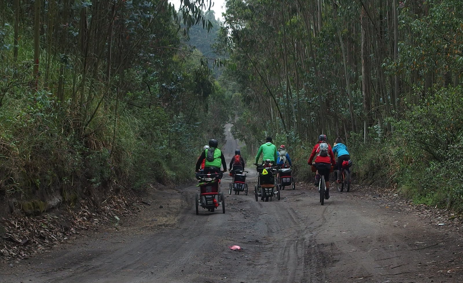
-- Saliendo de Guamote rumbo a las lagunas de Atillo. Para esta corta seccion se nos une "tocayo" Mike Howarth.
-- Coming out from Guamote, heading to Atillo Lakes. "Tocayo" Mike Howarth joins for this section.
-- Cass and Krampus
-- Bajando al Valle del Rio Cebadas / Coming down to the Rio Cebadas Valley
-- " Te Vendo Trucha "
-- El Inga-ñan. Terreno pristino para las primeras ruedas en seguir estas aristas!
-- The "Inga-ñan". Pristine terrain for the first tracks riding this magnificent ridges!
-- 2 dias volando a 4300 metros / 2 days flying at 4300m
-- Amanecimos colgados de una arista a 4350 metros con cielo azul. Un par horas mas tarde llegamos a Tres Cruces y nos unirnos a las huellas del legendario "Capaq-ñan"
-- We woke up to blue skies perched on a ridge at 4350 meters. A few hours ahead we joined the historic "Capaq-ñan" at Tres Cruces.
(foto:Thomas Dammer)
(foto:Thomas Dammer)
(foto:Thomas Dammer)
(foto:Thomas Dammer)
-- El filo de Azufre
(foto:Thomas Dammer)
-- Laguna de Culebrillas
QUINTA SECCION
Ruta: Salimos de Cuenca por la ciclovia del Yanuncay hasta Baños, por chaquiñanes escondidos cruzamos al camino viejo que va de Turi a Gima y a Nabon. De Nabon a Oña y a San Lucas para salir por las orillas del rio Zamora a Loja. De Loja por el Podocarpus a Malacatos y a Vilcabamba para asi terminar esta aventura de 25 dias y 1.300 kilometros de paramos andinos!
- Distancia (5ta Sección): 287 Km
- Distancia total Trans Ecuador: 1.300Km
- Dias (5ta Sección): 4 dias
- Total de dias: 25
- Desnivel positivo (5ta Sección): 6.960 m
- Desnivel positivo Trans Ecuador: 34.000 metros
- Altura maxima / Max. Elevation (5ta Sección): 3.500 m
_______________________
FIFTH SECTION
General Directions: We came out of Cuenca on the trail that follows the shores of the Yanuncay River to reach Baños. Some hidden single track took us to the old road that goes from Turi to Gima and Nabon. Oña and San Lucas followed to then take the Zamora river canyon to Loja. Up to the ridges of the Podocarpus to reach Malacatos and finally Vilcabamba. The end of this 25 day adventure that crossed 1.300 kilometers of ecuadorian highlands!
- Distance (5th Section): 287 Km
- Trans_Ecuador Total Distance: 1.300 Km
- Days (5th Section): 4 days
- Total days: 25
- Elevation Gain (5th Section): 6.960 m
- Trans-Ecuador total elevation gain: 34.000 m
- Highest Elevation (5th Section): 3.500 m
-- Mapas / Looking at Maps (Cuenca)
-- Nabon-Oña
-- Taller de Bicis / Local Bike Shop (Deleg)
-- Quebrada que fluye al encuentro con los nacimientos del Rio Zamora (Loja) /
-- "S" shaped ravine flowing into the headwaters of the Zamora River (Loja)
-- Lodo marca "podocarpus" / Podocarpus mud!
(foto:Thomas Dammer)
-- Adobes (Malacatos)
-- Con esta foto se termina en Vilcabamba una aventura deliciosa, llena de encuentros mágicos sobre estos caballitos de dos ruedas que trazaron el
Trans Ecuador. Gracias a estos porotos y sus Mamas que nos cubrieron la espalda a lo lejos.
-- With this photo we end at Vilcabamba a delicious adventure riding on this two wheeled horses. As a result we drew a line that weaves together the
"Trans Ecuador". Thanks to those "wee" little kids and their Mamas that covered our backs from the distance as we rode.


